second title

Thanks to the introduction of E-Mountain Bikes, (pedal- assisted), this has now become an activity us old timers can partake. These bikes take the "grunt" out of climbing the hills and going the distance, making it a relaxing, enjoyable ride.

.

Thursday, January 31, 2019

January 28 2019 - Circle Route, stopping at the Gillnetter Pub - 16.61 miles

Today, we decided to go on our Circle Route, stopping half way at the Gillnetter Pub for lunch; Greg Huurman was a pleasant addition to our group ride.

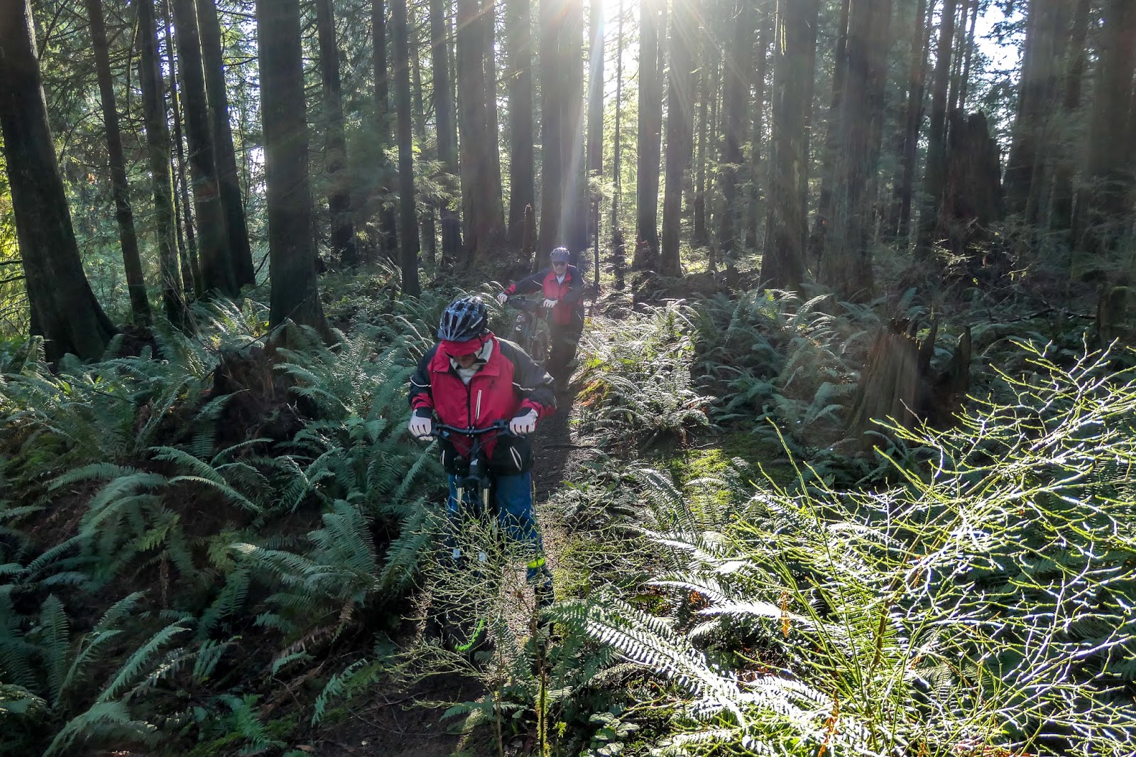
We went through the old River View Hospital site (or by the locals, the area was called "Essondale").
Apparently, we found out that this site is the number one movie site in North America!! Nice that Port Coquitlam town is recognized in the movie industry.

Along the way, we meet a couple of riders at the Coloneyfarm bridge; they are working for the Trails BC Website , A website well worth looking at  (I have added this site to our "Resource Link" tab).

We stopped a the Gillnetter pub for a ice tea, and a quick lunch... great pub, with a wonderful view of the Fraser River, bicycle parking, and good food! :)

Part way home, Merrill branched off and headed for his home, as it was on our route back to the "barn".

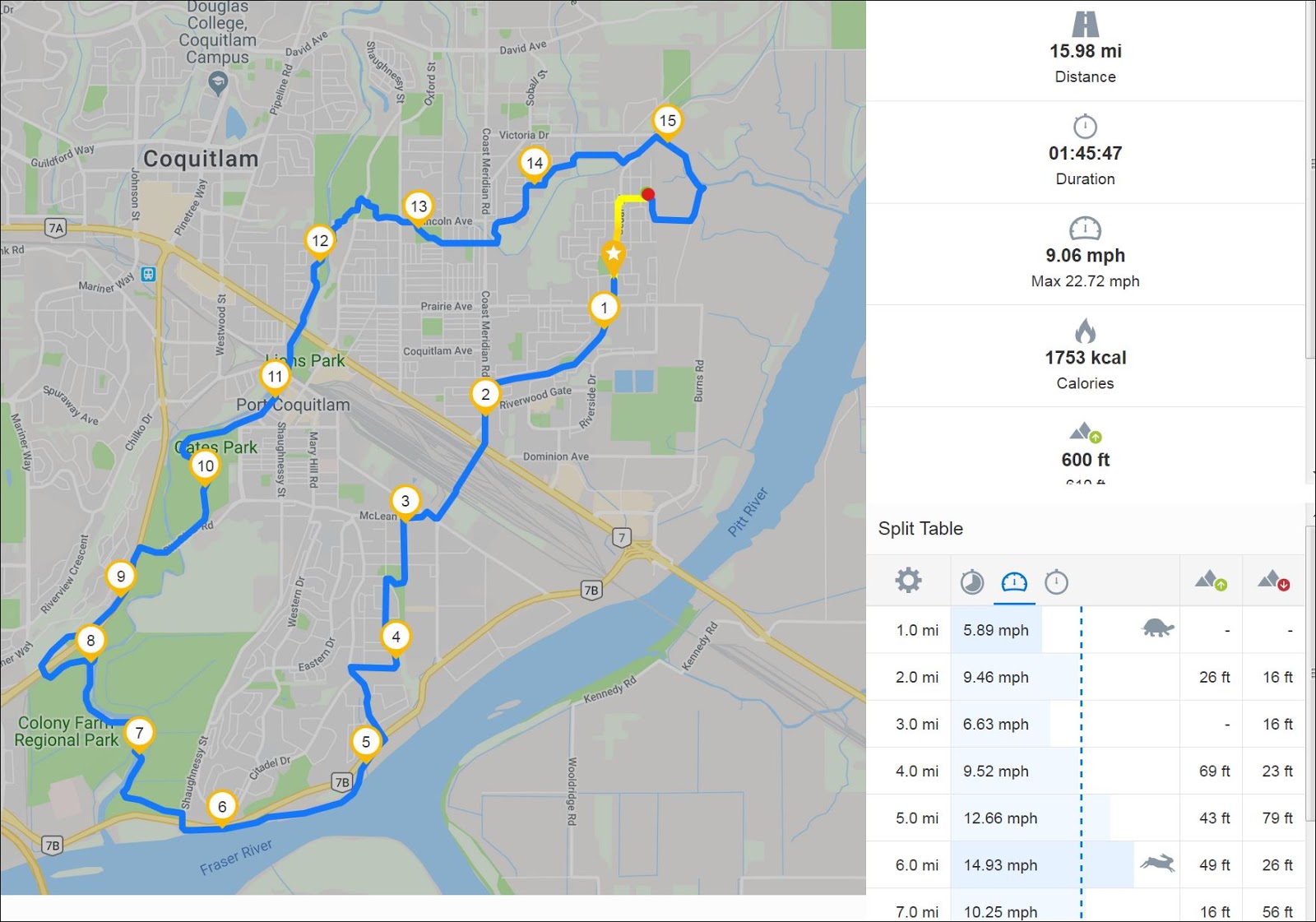
all and all... a great ride today, perfect weather, perfect friends, perfect food and perfect excerise....


At "Essondale"... making a movie there

Bridge over the Coquitlam River, at Colony Farm


At the Gillnetter Pub, Port Coquitlam

Friday, January 25, 2019

January 25 2019 - Circle Route through town (11.34 miles)

Finally a break in the weather to pull off a ride (sorry no pictures this time). Due to limited time, we decided to take a short trip through Port Coquitlam, along the Pitt River dike and back to the garage.

Rick setting the pace... a quick ride with less stops along the way.

On the graph below, you can see the stops, stop times and out speed along the way.

Runtastic map
 Starting the red dot, we rode through the town center (from 1 to 4), then up onto the dikes (from 5 to 10) then back to the garage (11).


The speed noted on the graph is somewhat off... showing us going way too fast, but it shows our consistent speed.

Wednesday, January 16, 2019

Ride to Minnekhada Park and Tech trails R, M, G, H


Wow, three days in a row bike riding! don't forget, we are all riding E-Mountain Bikes. I'm sure if we had the non-electric, we would of NOT be able to do so many miles. The E-Bikes have opened up a hold new adventure for us seniors!

Only 10.2 miles today…

Today we decided to ride our local trails and dikes… taking the dikes to Minnekhada Park (1-4), up through the tech trails (6 - 8)... loop around the trails behind school grounds (10) then back on the dikes heading for the garage.

Runtastic map... the numbers represent the miles driven.
view from dike overlooking the Pitt River Boat Club

Greg
a view on the dike near Minnekhada Park
Picture of Merrill, Greg and Hank, needless to say, it was cold that day.


more of the same
At the end of the dike, turning around going back (just north of mile 3)
No.... just looking to see if the trail continues on
Speed and elevation map
From the map above, you can determine our stopping spots and for how long. The map shows the incorrect speed (on the right) I think the scale is a bit off... max speed was around 22 mph.

Tuesday, January 15, 2019

Thornhill single track mountain trails. R, M & H

Only a 4 mile ride, but single track and very technical for the first part. See, we are not always doing 30 km rides :).

We took advantage of the really good weather today, and decided to take a trip over to Maple Ridge, Thornhill area, to explore some new to us riding trails.

We loaded up the bikes onto the rack and within a half hour we were there! Luckily there were some mountain bikers just ready to leave, giving us the opportunity to inquire about the trails. They stated that most of the trails come back to the parking lot, and are in good shape...

Rick getting ready to ride


Merrill all set to go!


started at 4, going up, then left, down 1 back to the parking lot, then up again, taking trail 2, then the road 3 back to 4.

We started at 4, going up (north) the service road (yellow line), then took the single track, going left and then down 1. Going down 1 was a very technical trail, more than a bit of a work out. Needed to walk in places. But a lot of fun. Trail 2 was very very good, but took us away from the parking lot. We had to ride on the paved road back to the truck (3).

Super large ferns!!


Merrill going across some wooden bridges


Merrill with a smile :)


As you can see above, the first part was very slow going coming down... lots of roots, pot holes, etc. the second half was great, but took us away from the parking lot. We needed to take the pave road back to the truck.

Monday, January 14, 2019

Ride to Runway Cafe, Pitt Meadows.


Today’s ride…18.55 miles

 We're off to Pitt Meadows Airport… for lunch at the Runway Cafe, owned by Alan Ford.

We started off going along the dike beside the Pitt River (2), heading to the bridge (4), then going under the bridge, on the dike again along the Pitt River (5-9), stopping off for lunch at the Runway Cafe
Runtastic map... the numbers represents the miles travelled.
  We found that this little cafĂ© is the perfect “watering hole” midway during our bike trip; they also serve wonderful lunches at a respectable price. They seem to go out of their way to cater to us “bikers”... offering bicycle parking, clean washroom, cold drinks and even a patio overlooking the airport…Highly recommended.


Leaving the airport, we rode along the gravel trail, longside the airport fence, until reaching a great little gravel trail going through the treed section...(between mile 10 & 11). The next section was on the bike lane going through Pitt Meadows town. Then taking the paved bike trail (mile 12 - 14) alongside the Lougheed Highway. This paved trail is great, but the noise from the traffic is something else! But I do have to say, I was impressed that the entire paved trail was salted! Pitt Meadows sure go out of their way to look after their trails. :)

Bike lane going over the Pitt River Bridge

The view at the crest of the bridge

Golden Ears Mountains
 The view at the crest of the bridge always looks great! with the Golden Ears Mountains in the background.

At this point, Merrill branched off for home, leaving Rick and I to make our way back to the "barn".


Below is a chart from Runtastic showing our speed over time. (the speed is a little off, was we can only do 20 mph... but the graph shows our rest times. :) 


Sunday, January 13, 2019

Ride through the Jungle of people

Well, today Rick, Greg and I went for a 16 mile bike ride

 My title "ride through the Jungle" pertains to the people on the trails... begin Sunday on a sunny day, everyone including their dogs are out for a walk. You have to be constantly aware of the people... they take up the entire trail at times.

We headed towards Mary Hill subdivision, (1 through 5 below), then along the POCO trail, through Colony Farm (6 to 10), then along the Coquitlam River trails. Number 15 is where the technical trails are located... then headed for Home base (Rick's place).

Overall nice ride... Rick set the pace, averaging 9.06 mile per hour (includes stop times)

Maps from Runtastic.


Monday, January 7, 2019

Ride going UP Burke Mtn. then riding down David Ave.

Great ride today with Rick and his son Greg. We rode up Coast Meridian area - Burke Mtn (1,080 ft) riding through the new subdivision areas. The paved hills very steep in places, but with the "turbo" mode on it was just a "walk in the park" (well almost). Near the very top of Coast Meridian - Burke Mountain  we took a single track trail (no. 5 in the map below) going through fields of ferns and tall cedar trees.

In some places we had to walk our bikes, due to the mud on the trail... the "walk" feature on our Cube bikes sure were helpful! Once at the top of the trail, we rode back on the same trail, down to David Ave (No. 7) ... taking the POCO Trail, down along the west side of the Coquitlam River, going over the walk bridge (no. 8), then back Home

Sunny, but cold... after the 10-mile ride, back to the garage to recharge the batteries and jump into the hot tub to warm up.

Runtastic Map
Rick and Greg beating through the ferns
Rick using the "Walk" mode
Greg on his Haibike

Father and son rides again!